East Central Florida - Thursday October 12, 2023: The National Weather Service NWS in Melbourne reports that temperatures ended up near normal with rainfall near to above normal across east central Florida in September.
After a very hot August, average temperatures for September were not as extreme as the previous month, and a couple weak cold fronts did bring some minor drops in temperatures.
A stalled frontal boundary across the region late in September also increased cloud cover and shower and storm coverage, keeping temperatures near to slightly below normal. Heavy rainfall that occurred during the last several days of the month boosted precipitation totals, with rainfall for September ending up near to above normal across much of the region.
Temperatures
A weak cool front moved through on the 2nd of September and did allow temperatures to fall to near to slightly below normal values for a few days following. Highs typically ranged in the upper 80s to low 90s and lows fell into the low to mid 70s, with minimum temperatures as low as the upper 60s at some sites.
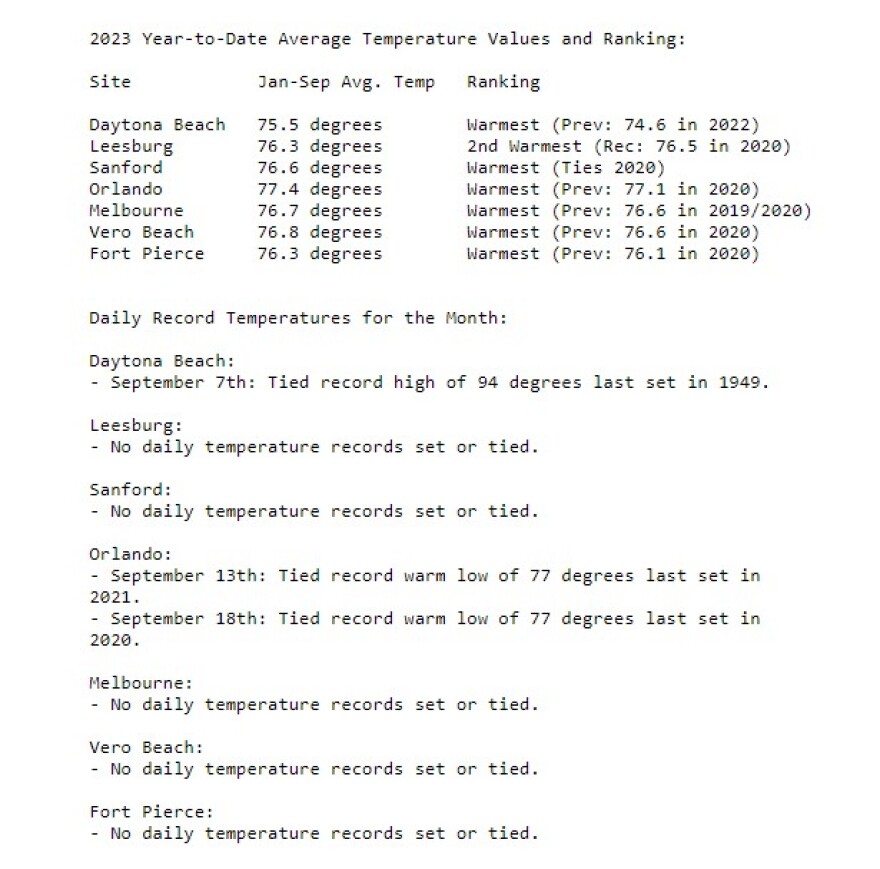
A warming trend then took hold after the 5th, with highs reaching into the low to mid 90s, and Daytona Beach tying their daily record high of 94 degrees on the 7th. Increasing coverage of showers and storms briefly led to another slight drop in temperatures on the 8th before another gradual warming trend set in through mid-month.
Temperatures continued to be near to slightly above normal for several days, with highs ranging from the upper 80s to mid 90s at times, and lows often in the mid to upper 70s through the 17th.
Another weak front that pushed southward across the area on the 18th and then shifted back north before finally shifting farther southward on the 21st. North to northeast flow that developed behind this boundary and well to the west of Tropical Storm Ophelia then ushered in some of the coolest air of the season so far. The lowest temperatures for the month occurred on the morning of the 23rd across east central Florida, with lows falling to the low to mid 60s for much of the region. For some sites, these were some of the lowest temperatures seen since late May or early June of this year.
A front then approached and eventually moved in and stalled across central Florida the last several days of the month. This increased rainfall and cloud cover keeping highs in the 80s and lows in the 70s to end September, which were near to slightly below normal.
September was quite a shift temperature-wise from the previous month, with only a few warm temperature records being set or tied, compared to the numerous high and warm minimum temperature records tied or broken in August. Average temperatures for September 2023 ended up within a degree of normal at all of the primary climate
sites, ranging from 1.3 degrees above normal at Orlando and 0.8 degrees below normal at Leesburg. September 2023 was just shy of making it into the top ten warmest at Orlando, tying September 2020 and 1933 as the 11th warmest September on record at this site.
Despite this shift closer to more normal values in September, year-to-date average temperatures were still the warmest or 2nd warmest on record for all primary climate sites.


