Update as of 1 PM Monday:
As of 1 PM CDT Monday, Tropical Storm Fred was located 35 miles SW of Apalachicola Florida and moving NNE at 9 mph. Maximum sustained winds were up to 65 mph, and the cyclone's minimum central pressure was 994 mb.
Update as of 11am Monday:
Fred continued to gain strength on its approach to the Florida Panhandle and Big Bend. Top sustained winds were 60 mph as of the 11am advisory. Hurricane Hunters found a larger area of tropical storm force winds, defined as winds greater than 39 mph. For that reason, the Tropical Storm Warning was extended eastward to Steinhatchee.
Heavy rainfall is already spreading inland from the Nature Coast area northward and westward into the Big Bend and eastern Panhandle as of midday. Isolated tornadoes are possible this afternoon and evening, and a Tornado Watch is in effect until 8 PM ET / 7 PM CT from Panama City eastward to Marianna, Tallahassee, Madison, and Perry, and southward to the Gulf of Mexico.
The strongest rain bands should diminish by around midnight; however, lingering bands could continue into Tuesday over the Big Bend and Nature Coast areas.
Original Update from 5am Monday:
Tropical Storm Fred was gradually gaining strength and slowing down as it approached the Florida Panhandle Monday morning, with landfall expected near Panama City Monday afternoon.
As of 400 am CDT Monday, Tropical Storm Fred was located 160 miles S of Panama City Florida and moving N at 9 mph. Maximum sustained winds were up to 50 mph, and the storm's minimum central pressure was 1002 mb.
Heavy rain and isolated tornadoes are the primary hazards across inland areas near and east of its path, with minor wind damage and storm surge flooding expected along the Gulf Coast.

A Tropical Storm Warning continues from Navarre Beach to the Wakulla/Jefferson County line, including all inland areas from Crestview to Tallahassee.

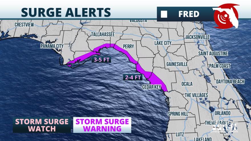
A Storm Surge Warning continues from Indian Pass to Yankeetown, including Apalachee Bay.

A Flash Flood Watch is also in effect through Monday evening for the same inland areas under the Tropical Storm Warning.
Rainfall amounts from Fred are expected to range from 4 to 8 inches in and around areas near Panama City, Marianna and Tallahassee. Locally higher amounts are possible where more persistent rain bands are established as Fred's center moves inland. 2 to 6 inches of rain are possible from Fred roughly from Tallahassee to Lake City, then points south and west in the Suwannee River Valley and along Florida's Big Bend. Lighter rainfall amounts of 1 to 3 inches are expected for areas farther east toward Gainesville and Ocala in North-Central Florida, along with locations west of Fred's track to from Crestview to the Emerald Coast.

Storm surge flooding of 3 to 5 feet above normally dry ground is expected along the coast from Apalachicola to Steinhatchee, with an inundation of 2 to 4 feet possible as far east and south along the Nature Coast to Yankeetown. The highest water levels will likely occur at high tide or just before Fred's center passes to the north, which will be at 9:30 am EDT in Apalachicola and 7:55 am in Cedar Key.

Minor wind damage may occur from tropical storm force winds up to 60 mph near and just east of where Fred's center comes ashore. The greatest risk for winds this strong will be between Destin and Apalachicola, arriving in the morning hours Monday. Top winds of 40 to 50 mph may extend inland to the I-10 corridor between Crestview and Tallahassee by early afternoon. Winds of these magnitudes could cause sporadic power outages from fallen trees and power lines, with some property damage to unsteady structures.

A few tornadoes could be spawn from Fred's outer rainbands, aided by the low-level spin of the tropical cyclone. The risk for a brief tornado is greatest on the eastern side of Fred's path, extending as far east as the I-75 corridor in North Florida Monday afternoon and early evening.
Tropical Storm Fred is expected to weak rapidly after moving inland Monday evening and crossing into southeastern Alabama overnight. There are two other systems in the tropical Atlantic basin - Tropical Depression Grace and Tropical Depression Eight (TD Eight), but they pose no threat to the State of Florida in the next five days. Grace is struggling to survive interactions with land and wind shear in the northern Caribbean and expected to move well to the south of the Sunshine State. TD Eight is located just east of Bermuda and expected to intensify into the season's next named storm (Henri), but forecast to turn back out to sea by the end of the week.
Copyright 2021 Storm Center. To see more, visit . 9(MDA4MjgzNjQ1MDEzMTc5MzUzNzIxNjNmZg004))


