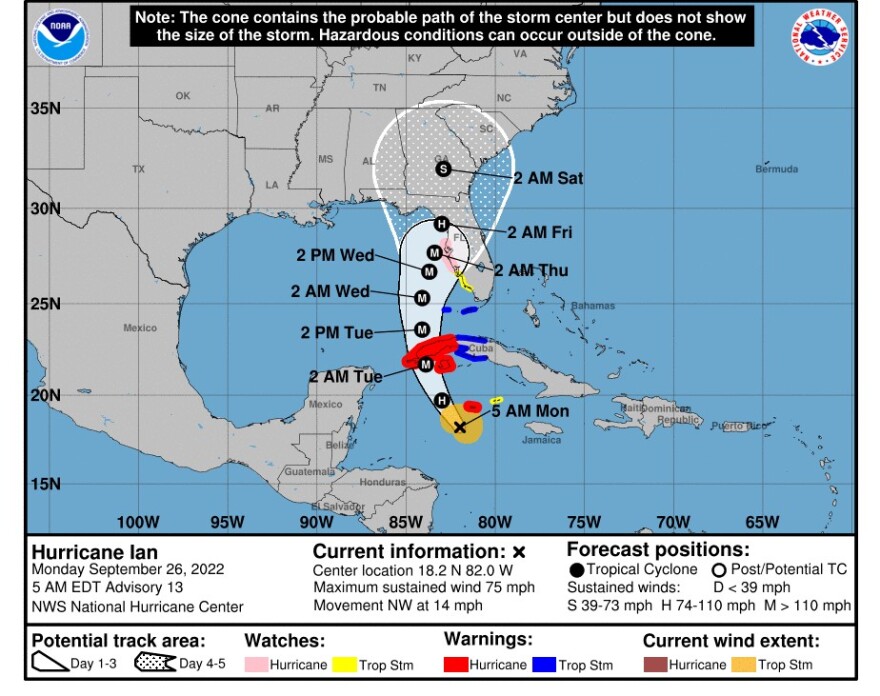
Florida - Monday September 26, 2022: The National Hurricane Center reports that Tropical Storm Ian reached minimal, Category 1, hurricane strength overnight. As of 5 AM Monday morning it had maximum sustained winds of 75 MPH and was heading northwest towards western Cuba at 14 MPH.
Hurricane Ian is expected to be a major hurricane by the middle of this week as it picks up strength over the eastern Gulf of Mexico.
It was located about 90 miles west-southwest of Grand Cayman Island and 275 miles southeast of the western tip of Cuba. Hurricane-force winds extended up to 15 miles from the storm's center, while tropical-storm-force winds extended outward up to 90 miles.
The forecast track of Hurricane Ian shifted a bit east overnight, it now shows a possible landfall in the Tampa area perhaps by early Thursday, rather than the panhandle on Friday. But forecasters emphasize the track remains uncertain and could change once again. And while southeast Florida still remains outside the cone of damaging winds, forecaster warn that heavy rain and flooding remain a threat.
Regardless of Ian's exact track and intensity, the National Hurricane Center warns there is a risk of life threatening storm surge, hurricane force winds, and heavy rainfall along the west coast of Florida and the Florida panhandle by the middle of this week.

Advisory 13: 5 AM Monday September 26
Considerable flooding impacts are possible later this week in west central Florida. Additional flash and urban flooding, and flooding on rivers across the Florida peninsula and parts of the southeast cannot be ruled out for later this week.
Tropical storm and hurricane watches have been issued for a portion of the west coast of Florida and additional watches maybe required later today.
Efforts to protect life and property should be rushed to completion.
Throughout Monday and Tuesday Ian is expected to produce heavy rainfall and instances of flash flooding and possible mudslides in areas of higher terrain, particularly over Jamaica and Cuba. Life threatening storm surge and hurricane-force winds are expected in portions of western Cuba beginning late today, and Ian is forecast to be at major hurricane strength when it is near western Cuba.


