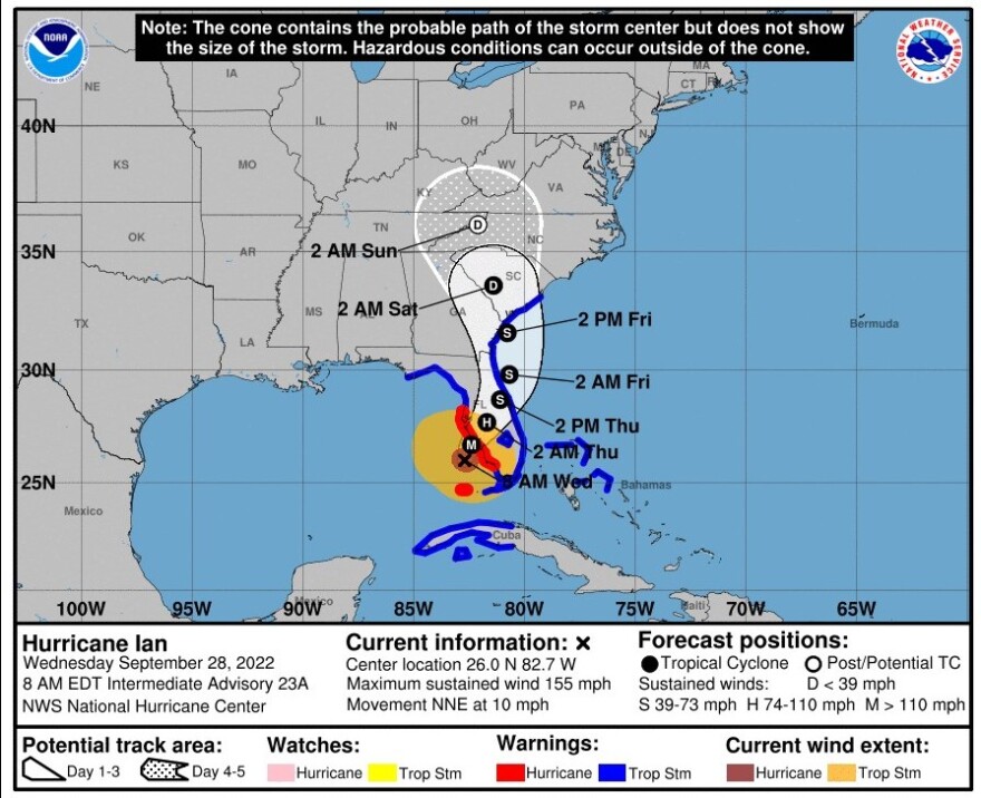
Florida - Wednesday September 28, 2022: As of 8 AM Wednesday morning, September 28, the National Hurricane Center reported that Hurricane Ian had strengthened to a major Category 4 Hurricane. It is forecast to make landfall on the west coast of Florida as a catastrophic hurricane with sustained winds of 155 MPH.
Weakening is expected after landfall, along with a reduction in forward speed, followed by a turn toward the north on Thursday as it makes its way across the Florida Peninsula and into the Atlantic.
Ian is expected to cause a catastrophic storm surge, winds and flooding over portions of the Florida Peninsula later today.
LOCATION: At 8 AM EDT the eye of Hurricane Ian was located by Air Force and NOAA Hurricane Hunter data plus Key West radar about 55 miles west of Naples, near 26.0N 82.7W.
TRACK: On the forecast track, the center of Ian is expected to move onshore within the hurricane warning area early afternoon. The center of Ian is forecast to move over central Florida tonight and Thursday morning and emerge over the western Atlantic by late Thursday.
MOVEMENT: It was moving north, northwest at 9 knots. The minimum central pressure was 937 millibars.
WINDS: : The maximum sustained winds remain near 155 mph with gusts up to 189 MPH. Ian is a strong category 4 hurricane.
Catastrophic wind damage is likely where the core of Ian moves onshore. Hurricane conditions will begin along the west coast of Florida within the Hurricane Warning area later this morning.
Hurricane force winds extend out 35 nautical miles from the center. Tropical storm force winds extend out 120 nautical miles in the northeast quadrant, 130 nautical miles in the southeast quadrant, 100 nautical miles in the southwest quadrant and 150 nautical miles in the northwest quadrant.

RAINFALL: Ian is expected to produce the following storm total rainfall:
* Florida Keys and South Florida: 6 to 8 inches, with local maxima up to 12 inches.
* Central and Northeast Florida: 12 to 18 inches, with local maxima up to 24 inches.
* Eastern Georgia and Coastal South Carolina: 4 to 8 inches, with local maxima of 12 inches.
SURF: Swells generated by Ian are affecting the northern coast of Cuba, the northeastern coast of the Yucatan peninsula and the west coast of Florida. Swells will increase along the east coast of Florida, Georgia, and South Carolina tonight and Thursday. These swells are likely to cause life-threatening surf and rip current conditions.
TORNADOES: Tornadoes are possible today and tonight across central and south Florida.
SURF: Swells generated by Ian are affecting the northern coast of Cuba, the northeastern coast of the Yucatan peninsula and west coast of Florida. Swells will increase along the east coast of Florida, Georgia, and South Carolina tonight and Thursday. These swells are likely to cause life-threatening surf and rip current conditions. Please consult products from your local weather office.
SEAS: Seas of 12 ft or greater extend out 120 nm E semicircle, 270 nm SW quadrant and 210 nm NW quadrant. Peak seas are 29 ft. Numerous strong convection extends from 23N to 28N between 80W and 85W.
Numerous moderate to isolated strong convection in banding extends from 23N to 31N between 75.5W and 80W.


