During the colder months of the year, National Weather Service meteorologists have an arsenal of alerts that can be issued ahead of impactful weather.
Being in the Deep South, the issuance of many of these alerts is infrequent, but when they are issued, it is often a prelude to a historic event.
One example is the winter storm that impacted the area in January 2025, which forced the issuance of everything from Winter Weather Advisories to Blizzard Warnings - with some communities under alerts for the first time ever.
Here are the weather alerts you could find yourself under and the criteria for when they are issued.
Frost Advisory
Counties can be placed under a Frost Advisory when air temperatures are forecast to drop to between 33 and 36 degrees and the mercury reaches the dew point.
Several other ingredients are needed for frost to form, including sufficient surface moisture, calm winds and mostly clear skies.
The first Frost Advisories of the season usually occur in November along the Interstate 10 corridor from Pensacola to Jacksonville.
For communities along the Interstate 4 corridor, the season’s first frost typically doesn’t occur until at least late December.
Within the NWS alert bulletin for a Frost Advisory, meteorologists remind the public that conditions may damage sensitive vegetation and outline the steps needed to protect plants from the cold.
One of the most effective ways to protect plants is by placing a covering over them to help insulate against the cold.
If possible, the best course of action is to move plants indoors to avoid the formation of ice crystals.
The issuance of the advisory can be suspended for a particular region once a significant, widespread event occurs and there are no lingering concerns about further crop damage from future frosts.
Frost Advisories are typically issued 12 to 24 hours in advance of a cold spell and run for several hours.

Freeze Watch
A Freeze Watch is issued when there is a likelihood that temperatures will dip to 32 degrees or below within the next 24 to 36 hours.
Once the event gets closer in time and confidence increases, the watch is upgraded to a Freeze Warning.
The first freeze event typically occurs in late November or early December in North Florida, while Central Florida can see freezing temperatures in January.
A Freeze Watch does not take wind chill values or expected frost into account - both of which are covered by other alerts.
Freeze Warning
A Freeze Warning is issued when a widespread area is expected to see temperatures reach the freezing mark or lower.
These alerts are typically issued 12 to 48 hours ahead of an event and remain in effect for a minimum of two hours.
On nights when temperatures are expected to fall to 32 °F or below, it is imperative to take action to protect the “7 Ps”: people, pets, plants, pipes, pools, vehicles and to practice fire safety.
According to records dating back to 1986, every Florida county except one has been placed under a Freeze Warning. The lone outlier is Monroe County, home to the Florida Keys.
The coldest observation ever recorded in Key West was 41 degrees in January 1981.

Cold Weather Advisory
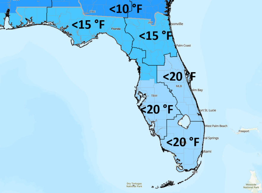
This alert is issued up to 24 hours in advance when air temperatures or wind chill values are expected to fall below 25 °F across North Florida, 30 °F across Central Florida and 35 °F across South Florida.
The “Cold Weather Advisory” designation debuted in 2024 as part of NOAA’s hazard simplification initiative, replacing what was previously known as a Wind Chill Advisory.
An air temperature of 35 degrees with a wind of 5 mph makes the real-feel temperature feel like it is 31 degrees. If wind gusts are even greater, temperatures would feel even colder.

Extreme Cold Watch
An Extreme Cold Watch is issued when dangerous cold conditions are possible, but the exact timing and intensity of the weather event are still uncertain.
Extreme cold is defined as air temperatures or wind chill values expected to fall below 15 °F across North Florida, 20 °F across Central Florida and 35 °F across South Florida.
Prior to the NWS hazard alert revamp in 2024, similar conditions were warned by either a Hard Freeze Warning or a Wind Chill Warning.

Extreme Cold Warning
When dangerous cold is occurring or is imminent, the most critical alert that can be issued is an Extreme Cold Warning.
Extreme cold is defined as air temperatures or wind chill values below 15 °F across North Florida, 20 °F across Central Florida and 35 °F across South Florida.
When the alert is in effect, meteorologists recommend avoid going outdoors and if travel is necessary, dressing in layers.
Frostbite can begin within minutes, and hypothermia can set in when the body’s temperature drops to dangerously low levels.
Health experts suggest wearing mittens or gloves and a hat to minimize heat loss.
Additionally, it’s important to dress in loose layers, as clothing helps trap air around the body, increasing insulation.


