-
 A stationary front and deep moisture in the atmosphere will bring several days of heavy showers and thunderstorms, keeping the threat of flash floods across the northern half of Florida this week.
 -
 Flash flood risk along Florida's East Coast, as there will be some slow movers. Widespread showers and storms for the beginning of the week. Higher rain chances remain focused over the areas experiencing the worst drought in Florida.
 -
 Temperatures could feel as high as 113F to start the week, with conditions changing later as more rain and storms return to the forecast.
 -
 Florida has one of the highest rates of air conditioning, with 99.5% of households reporting having access to cooling.
 -
 Tropical Storm Bertha made landfall north of the mouth of the Mississippi River on Wednesday. The threat for dangerous rip currents was expected to continue along the Gulf Coast.
 -
 The Peninsula had drier-than-usual conditions as Bertha was west of the state. The wind also left less hot afternoons across the western portion of the Peninsula, but as we wave goodbye to Bertha, rain and heat return to Florida. Let's look at this week's forecast.
 -
 Tropical Storm Bertha is producing dangerous surf and life-threatening rip currents for beaches along Florida's Panhandle.
 -
 Tropical Storm Bertha slowly drifts west-northwest across the northeastern Gulf of Mexico toward southeastern Louisiana. While strong wind shear is expected to limit rapid intensification, Bertha will bring prolonged tropical-storm-force winds, storm surge, and heavy rainfall to portions of the Florida Panhandle, the central Gulf Coast, and southern Louisiana through midweek.
 -
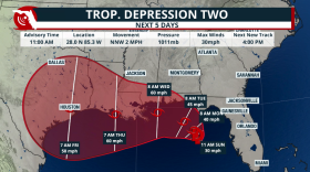 Tropical Depression 2 is set to become Tropical Storm Bertha as it travels mainly due west during the next few days. Gulf waters are warm and could strengthen this system if it stays well away from the Gulf Coast.
 -
 The Florida Keys are considered the waterspout capital of the world, producing hundreds each year. But not all waterspouts form the same way. Here's how to tell the difference between fair-weather and tornadic waterspouts—and why it matters for your safety.


Play Live Radio
Next Up:
0:00
0:00
Available On Air Stations


