


As we wave goodbye to another significant taste of winter, Tuesday night will be the last frosty night across North Florida, while South Florida will also have relatively cold temperatures in between the mid-40s and low 50s. Central Florida's lows will drop to the upper 30s by Wednesday morning.
Wednesday will continue with crisp conditions. The sunshine will continue to reign across the Peninsula, while the Panhandle will be under mostly cloudy skies. The clouds will build as winds from the Gulf move in. The high-pressure system will be centered over the Peninsula, and its clockwise circulation will bring southerly winds over cities like Pensacola and Tallahassee. Calm winds over Central and South Florida, while North Florida will have light winds from the southwest. The wind direction will cause temperatures to gradually rebound on Thursday and Friday.
Stable weather across the Peninsula after a cold start on Wednesday.
— Florida Public Radio Emergency Network (FPREN) (@FloridaStorms) February 25, 2026
The pattern starts to change as the winds bring more humidity, increasing the risk for showers to end the week and into the weekend for some. pic.twitter.com/GiH4mf45AO
Another cold front
The clouds and rain chances will increase on Thursday and Friday. Thursday will expect a few streamer showers across Central and Southwest Florida as the winds come in from the Gulf. A few more showers over the Panhandle will be possible as more moisture from the Gulf becomes available, along with instability from the next cold front approaching from the west.
The cold front will be coming from the west-northwest. Attached to a low-pressure system that will be traveling over the Carolinas. By Saturday morning, this cauldron will be slowing down in a week. A low-pressure system will be developing just over the north-eastern Gulf. Once the low-pressure system develops and a stronger front pushes south of the Great Lakes area, we can expect the cold front to cross the peninsula.


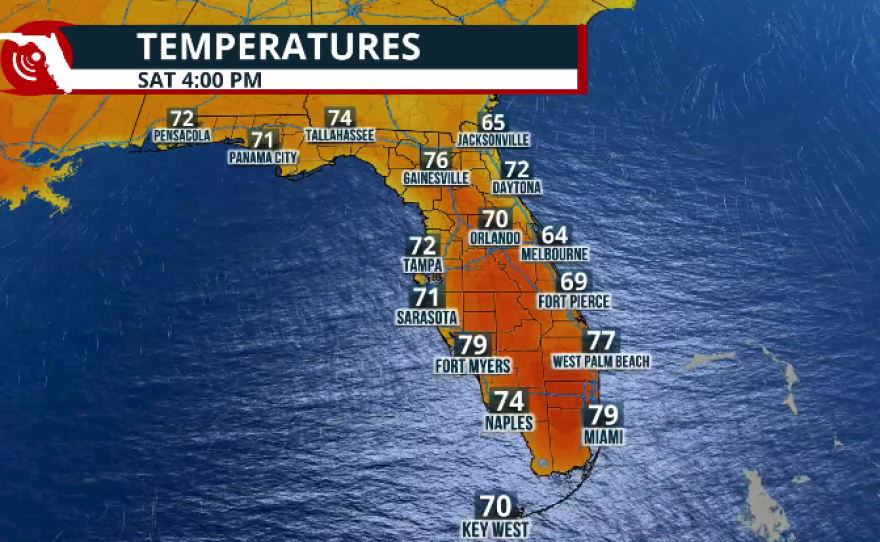
Temperatures over the weekend will not drop significantly, as the cold front is expected to be rather weak. The effects of the cold front will mainly be stronger, brief winds, allowing temperatures to be near normal across the Florida East Coast. The West Coast of Florida will remain slightly above average, by 2° and 5°, with temperatures during the afternoons on Saturday and Sunday.
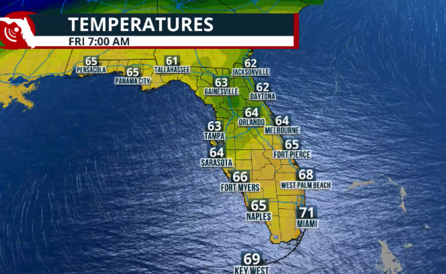
By the weekend, morning temperatures will be slightly above normal, ranging from the mid- to upper 50s across the panhandle of North Florida, while Central Florida will be around the mid-60s. South Florida will remain in the low 60s and upper 60s. These are all temperatures slightly above average by about 3°.
Last night with cold alerts across Florida? Likely so! pic.twitter.com/499cAN3Tr6
— Florida Public Radio Emergency Network (FPREN) (@FloridaStorms) February 25, 2026
As for the rain, we do not expect heavy precipitation from the cold front. on Saturday afternoon. There could be an isolated downpour across Central Florida, affecting areas from the Tampa Bay area to Melbourne. By Sunday morning, most showers will be focused across the Space Coast and South Florida, so far, it looks mostly dry throughout the weekend. There will be a bit more humidity over the weekend, even after the cold front pushes through, as the wind will quickly shift and come in from the east, keeping humidity levels at Bay, but still present.
Florida is in dire need of rain, as we continue to face a rainfall deficit and worsening drought. The next drought report will be released on Thursday morning and will include an update. We do not expect any improvement, as the recent rains were not significant enough, and the last cold front moved quickly across the state, leaving behind very dry air and the cold temperatures experienced at the start of the week.