


The July 4th holiday weekend will bring a weather pattern very similar to what we've experienced over the last several days across Florida.
Let's start with some good news. Florida's drought conditions improved over the past week. The latest U.S. Drought Monitor report, released on Thursday, July 2, shows that the state's most severe drought category—Extreme Drought—now covers about 18% of Florida. The peak of the extreme level was in mid-May, when about 82 percent of Florida was at the extreme level.

The remaining drought categories have changed very little. While this is certainly encouraging, it's important to remember that Florida is still recovering from one of the worst droughts in its recent history. There is still an abundance of dry vegetation across many areas of the state. As we head into a holiday weekend when fireworks are widely used, please make sure to extinguish them properly. Any outdoor activity involving fire or sparks can quickly ignite dry vegetation, leading to fast-spreading wildfires that become difficult to control.

The weather forecast for the holiday weekend
Hot and humid conditions will continue throughout the weekend, with temperatures running slightly above average for early July. The hottest temperatures will be found across northern Florida, where highs will climb into the mid to upper 90s. This is due to the proximity of a strong upper-level high-pressure system. High pressure promotes sinking air, and as air sinks, it compresses and warms, resulting in higher surface temperatures. Elsewhere across the state, including central and southern Florida, deep tropical moisture flowing in from the Gulf of Mexico will keep humidity levels very high. While actual temperatures will generally reach the lower to middle 90s, heat index values will climb well into the triple digits. Winds will remain primarily out of the south-southwest through the weekend. This wind pattern will favor the hottest temperatures across interior and eastern Florida, where air warms as it moves inland before reaching the Atlantic coast.
Independence Day weekend across Florida will be hot, and with the winds shifting, the strongest storms will be focused in the interior and along the east coast on the 4th. pic.twitter.com/u411WefwDd
— Florida Public Radio Emergency Network (FPREN) (@FloridaStorms) July 3, 2026
The southwesterly flow will also push the Gulf Coast sea breeze farther inland during the afternoon, allowing thunderstorms to develop over the interior before moving toward the East Coast. As a result, the strongest storms are expected to develop along the interior and then move eastward toward the I-95 corridor. This setup will be most noticeable on Saturday afternoon. Thunderstorms will continue into the evening, lasting until around 8:00 p.m. across areas south of Lake Okeechobee, while ending a bit earlier across parts of central Florida.


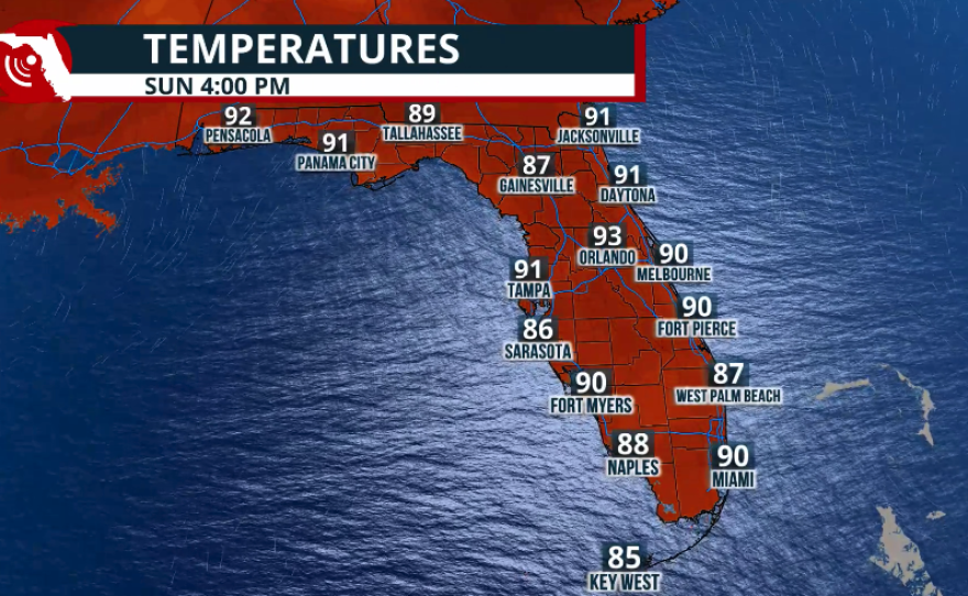

Sunday will feature a very similar weather pattern. Winds will continue out of the south-southwest, bringing another hot day across the state. High temperatures will range from the lower to middle 90s along the Southeast Coast and Space Coast, while Northeast Florida reaches the middle 90s. Across Southwest Florida and the Tampa Bay area, highs will remain in the lower 90s. However, thanks to a more persistent breeze off the Gulf, it won't feel quite as oppressive as it will farther inland. These areas will also have a lower chance of afternoon showers and thunderstorms, especially on Sunday, as any storms that develop will be steered eastward toward the interior and Atlantic Coast.

If you have outdoor plans this holiday weekend, try to limit your time outside during the hottest part of the day, generally between noon and 7 p.m.
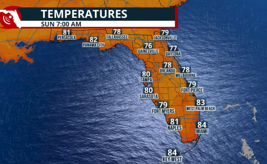
Mornings will also remain very warm and humid, with many locations struggling to fall below 77°F overnight. The combination of high humidity and hot temperatures will make conditions uncomfortable even early in the day.
If you are planning on a beach trip, make sure to know what the flags mean. Across the Panhandle, there is a risk of rip currents, as winds will be from the Gulf. Make sure to swim near a lifeguard or, better yet, avoid going in the water. Make sure to use sunscreen, as UV levels will be dangerously high.
Our meteorologist Andrew Wulfeck wrote about the expected holiday weekend's marine conditions here
Rip currents will be a threat this weekend across the majority of the Atlantic beaches. Use caution this Fourth of July weekend. pic.twitter.com/3kaulUg18w
— Florida Public Radio Emergency Network (FPREN) (@FloridaStorms) July 3, 2026
Sneak peek for next week
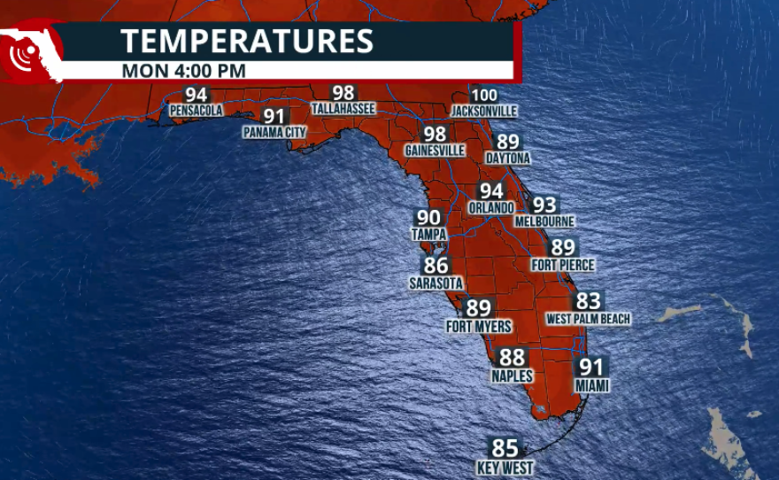
The hot pattern is expected to continue into next week. We're also monitoring the potential arrival of a Saharan Air Layer moving west across the Caribbean. If this dust plume reaches Florida, it could reduce thunderstorm coverage while creating hazier skies and colorful sunrises and sunsets. We'll continue to monitor its evolution and keep you updated on whether this Saharan dust layer will make its way into the Sunshine State.
