


Floridians can expect a noticeable change in the weather as a cold front moves through the Sunshine State, bringing cooler afternoons, refreshing mornings, and a welcome break from the usual warmth. A cold front sweeping across Florida is bringing a cooler air mass, with temperatures expected to stay below seasonal averages through the weekend. From Jacksonville and Orlando to Tampa, Miami, and Fort Lauderdale, residents will notice a significant change, especially in the early morning and evening. Afternoon temperatures across much of the state are forecast to run 5 to 15 degrees below average through the weekend, while overnight cooling will bring morning temperatures approximately 5 to 10 degrees below average over the next several days. Residents heading out early in the morning or staying outdoors after sunset may want a light jacket or sweater handy, especially across northern and central Florida.

Jacksonville will see some of the coolest weather, with crisp mornings and pleasantly cool afternoons. Residents heading outdoors early may want an extra layer, especially in inland communities where temperatures can drop quickly overnight. Temperatures will feel much cooler Friday morning, with lows in the mid-to-upper 40s along the I-10 corridor. Friday and Saturday nights will be colder, with lows in the upper 30s and low 40s. Rural spots that get frost could see patchy frost this morning. Friday highs will be in the mid-60s, but by Saturday afternoon temperatures will struggle to reach the low 60s. Bundle up!
The Orlando area, including nearby Kissimmee and Sanford, will enjoy a refreshing change from the typical Florida warmth. Afternoon temperatures will remain below normal through the weekend, while mornings will feel especially comfortable, making it ideal weather for outdoor activities and visits to Central Florida's theme parks. Friday will start mild, but cold air should move through Central Florida by the afternoon, keeping highs in the upper 60s to low 70s. Clear skies will let temperatures drop quickly after sunset; Saturday will start in the low 50s, and Sunday morning will be similar. Highs will remain in the mid-60s through the weekend, rising to the low 70s on Sunday as winds shift from the east. Tampa, St. Petersburg, and Clearwater will also feel the cooler air. Lower temperatures will make afternoons more comfortable, with noticeably cooler nights and early mornings. Coastal locations may experience slightly milder mornings than communities farther inland.
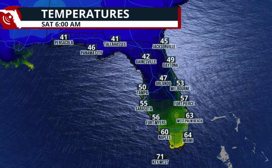
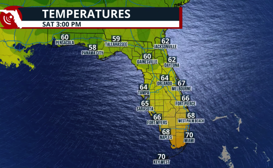
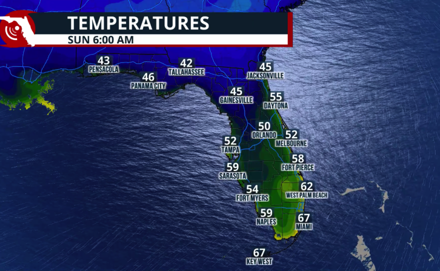
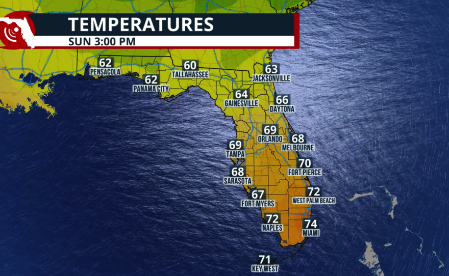
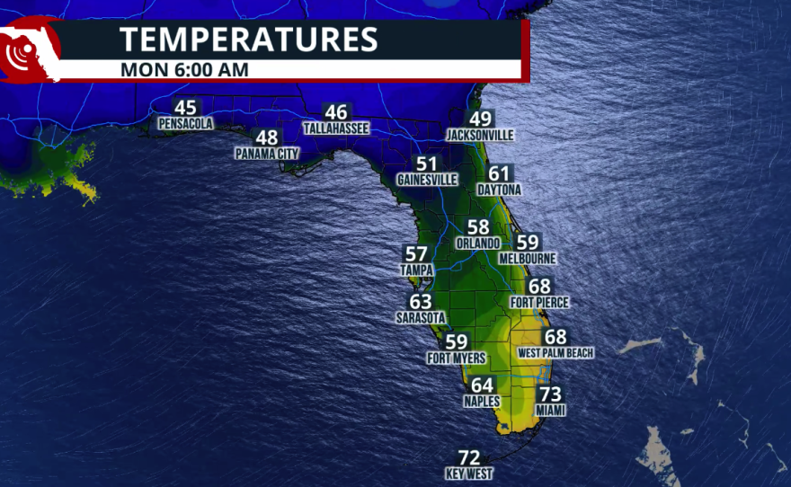
South Florida won't escape the cooldown. Miami, Fort Lauderdale, and surrounding communities can expect a break from the usual tropical warmth as the cooler air spreads southward. Although temperatures will generally remain milder than in northern Florida, afternoon readings will still trend below seasonal averages, with refreshing mornings continuing into the weekend. Communities along Florida's southeastern coastline will also experience low temperatures on Saturday morning in the upper 50s to lower 60s, with the cooler range staying in the suburbs. Saturday afternoon will be the coolest day of the weekend across South Florida, with highs barely reaching the low 70s from Naples to Miami and the Keys. East winds will bring temperatures back to the upper 70s on Sunday, still slightly below average, with mostly dry conditions.
How long will the cool weather last?
The cooler-than-average pattern is expected to persist through the weekend, rather than disappearing immediately after the front moves through. But keep in mind that winds will change by the end of the weekend, moderating temperatures, and they will rebound. A moist airmass will also move in from the south, which is forecast to increase rain chances, mainly through the southern half of the Peninsula, and more pronounced across the Atlantic Coast. Keep in mind that winds will be strong next week, which can bring hazardous seas, beach erosion, and a high risk of rip currents along Florida's east coast.
