Florida - Monday September 26, 2022: The National Hurricane Center has issued a Hurricane Watch for portions of Florida's west coast as Hurricane Ian continues to gain strength.
At 11 AM EDT, the center of Hurricane Ian was located about 100 miles west of Grand Cayman. Ian was moving toward the northwest near 13 mph.
Maximum sustained winds have increased to near 80 mph (130 km/h) with higher gusts.
Rapid strengthening is expected during the next day or so, and Ian is forecast to become a major hurricane tonight or early Tuesday when it is near western Cuba and remain a major hurricane over the southeastern Gulf of Mexico on Wednesday.
SEE the 11 am briefing from Acting National Hurricane Center Director Jamie Rhome HERE> https://fb.watch/fNzNePv3La/

On the forecast track, the center of Ian is expected to pass near or west of the Cayman Islands today, and near or over western Cuba tonight and early Tuesday. Ian will then emerge over the southeastern Gulf of Mexico on Tuesday, pass west of the Florida Keys late Tuesday, and approach the west coast of Florida on Wednesday into Thursday.
A north-northwestward motion is expected to begin later today, followed by a northward motion on Tuesday with a slightly slower forward speed.
A turn toward the north-northeast with a further reduction in forward speed is forecast on Wednesday.
WINDS: Hurricane-force winds extend outward up to 25 miles (35 km) from the center and tropical-storm-force winds extend outward up to 115 miles (185 km).
PRESSURE: The minimum central pressure based on Air Force and NOAA Hurricane Hunter aircraft data is 980 millibars or 28.94 inches.
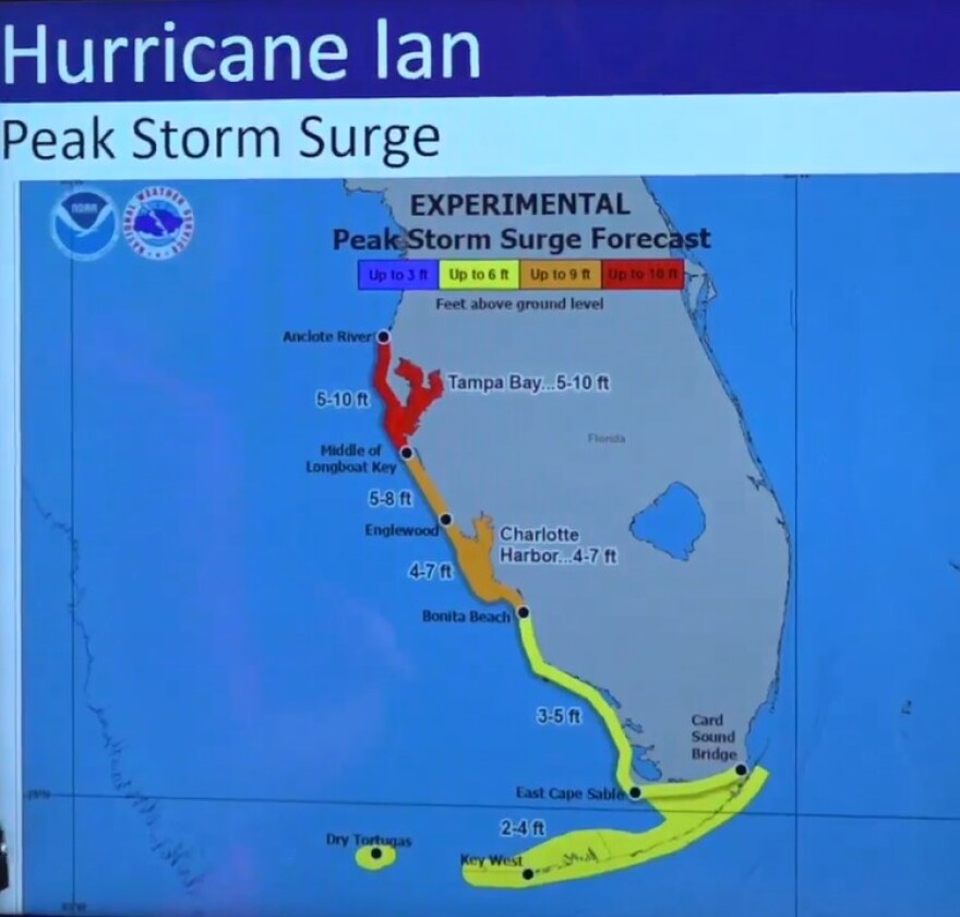
STORM SURGE: A storm surge of up to 10 feet is possible in the Tampa Bay area and 2 to 8 feet surges farther south along the west coast.

Storm surge is rising water moving inland from the shoreline, pushed onshore by the force of the wind.
This storm surge watch/warning graphic identifies locations most at risk for life-threatening inundation from storm surge, displaying areas that qualify for inclusion under a storm surge watch or warning by the National Weather Service.
Due to forecast uncertainty, the actual areas that experience life-threatening inundation may differ from the areas shown on this map.
All persons, regardless of whether or not they are in the highlighted areas shown by the graphic, should promptly follow evacuation orders and other instructions from local emergency management officials.


