Florida - Friday June 23, 2023: Tropical Depression #4 became Tropical Storm Cindy overnight, becoming the third named storm of the 2023 Atlantic Hurricane Season. It is now moving west-northwest and continuing to strengthen.
Tropical Storm Cindy Advisory Number 5 - 5AM Friday
There are no coastal watches or warning on Tropical Strom Cindy at this time.
LOCATION: 12.1N and 46.9W, about 990 miles or 1595 KM east of the Lesser Antilles
MAXIMUM SUSTAINED WINDS: 45 mph or 75 km/h
PRESENT MOVEMENT: West-northwest or 285 degrees at 15 mph or 24 km/h
MINIMUM CENTRAL PRESSURE: 1005 MB or 29.68 inches
OUTLOOK as of 5 a.m. EST Friday June 23: The center of Tropical Storm Cindy was located near latitude 12.1 North, longitude 46.9 West. Cindy is moving toward the west-northwest near 15 mph (24 km/h), and this general motion is expected to continue over the next few days. On the forecast track, the system is expected to remain well east and northeast of the northern Leeward Islands through early next week.
Maximum sustained winds are near 45 mph (75 km/h) with higher gusts. Tropical-storm-force winds extend outward up to 60 miles (95 km) from the center. Some strengthening is forecast during the next couple of days.
The estimated minimum central pressure is 1005 mb or 29.68 inches.

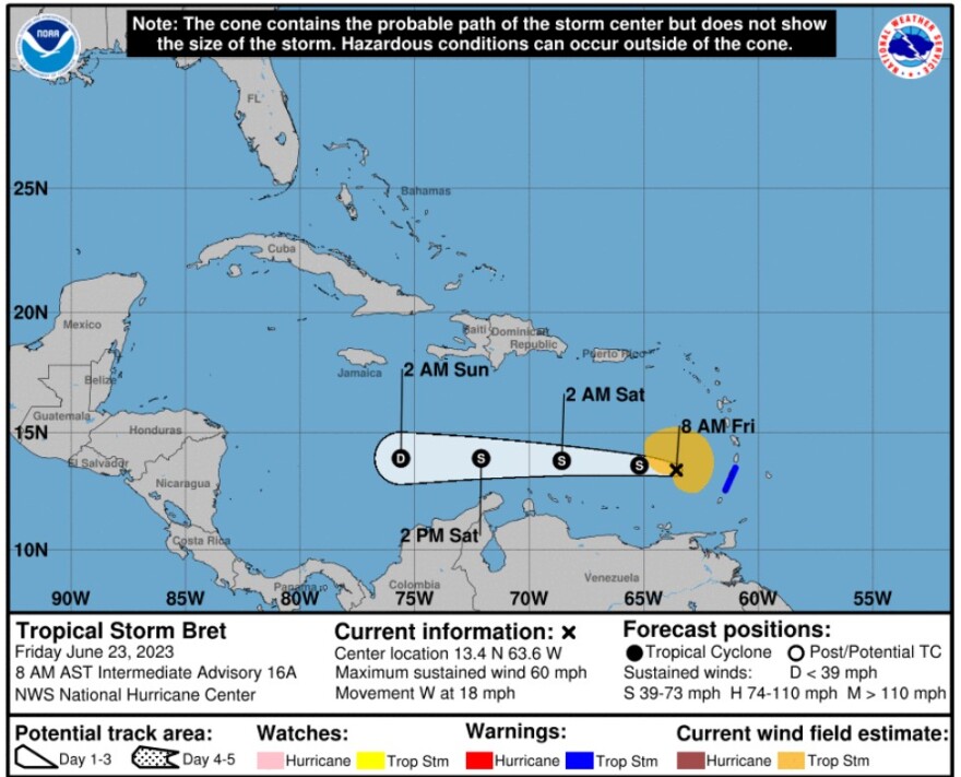
Tropical Storm Bret Intermediate Advisory Number 16A - 8 AM EST Friday June 23
As of 8 a.m. Friday, June 23, Tropical Storm Bret had moved west of the Lesser Antilles into the Caribbean Sea.
The government of St. Lucia has discontinued the Tropical Storm Warning for St. Lucia. The government of France has discontinued the Tropical Storm Warning for Martinique.
A Tropical Storm Warning remained in effect for:
* St. Vincent and the Grenadines
In this case, a Tropical Storm Warning means that tropical storm conditions are occurring within the warning area.
Interests adjacent to the southeastern Caribbean Sea should monitor the progress of Bret.
LOCATION: 13.4N and 63.6W about 160 miles or 260 KM west of St. Vincent and about 370 miles or 600 KM east-northeast of Curacao
MAXIMUM SUSTAINED WINDS: 60 MPH or 95 KM/H
PRESENT MOVEMENT: West or 270 degrees at 18 mph or 30 KM/H
MINIMUM CENTRAL PRESSURE: 1001 MB or 29.56 inches
OUTLOOK as of 8 a.m. EST Friday June 23: At 800 AM AST (1200 UTC), the center of Tropical Storm Bret was located near latitude 13.4 North, longitude 63.6 West. Bret is
moving toward the west near 18 mph (30 km/h), and this general motion is expected to continue through the weekend. On the forecast track, the center of Bret will continue moving westward away from the Windward Islands and across the eastern and central Caribbean Sea during the next couple of days.
Maximum sustained winds are near 60 mph (95 km/h) with higher gusts. Weakening is forecast during the next couple of days, and Bret is expected to dissipate over the central Caribbean Sea by Saturday night or Sunday.
Tropical-storm-force winds extend outward up to 125 miles (205 km) mainly to the north of the center.
The estimated minimum central pressure is 1001 mb (29.56 inches).
WIND: Tropical storm conditions are expected to diminish within the tropical storm warning areas later this morning.
RAINFALL: Storm total rainfall amounts of 3 to 6 inches with maximum amounts of 10 inches are possible across portions of the Lesser Antilles from Guadeloupe south through St. Vincent and the Grenadines, including Barbados. The heavy rainfall could lead to flash flooding, especially across areas of higher terrain. Urban
flooding is also possible.
SURF: Swells generated by Bret are expected to begin subsiding along the Lesser Antilles through the day. Swells are likely to increase in areas adjacent to the central Caribbean Sea later today and on Sunday. These swells are likely to cause life-threatening surf and rip current conditions.


