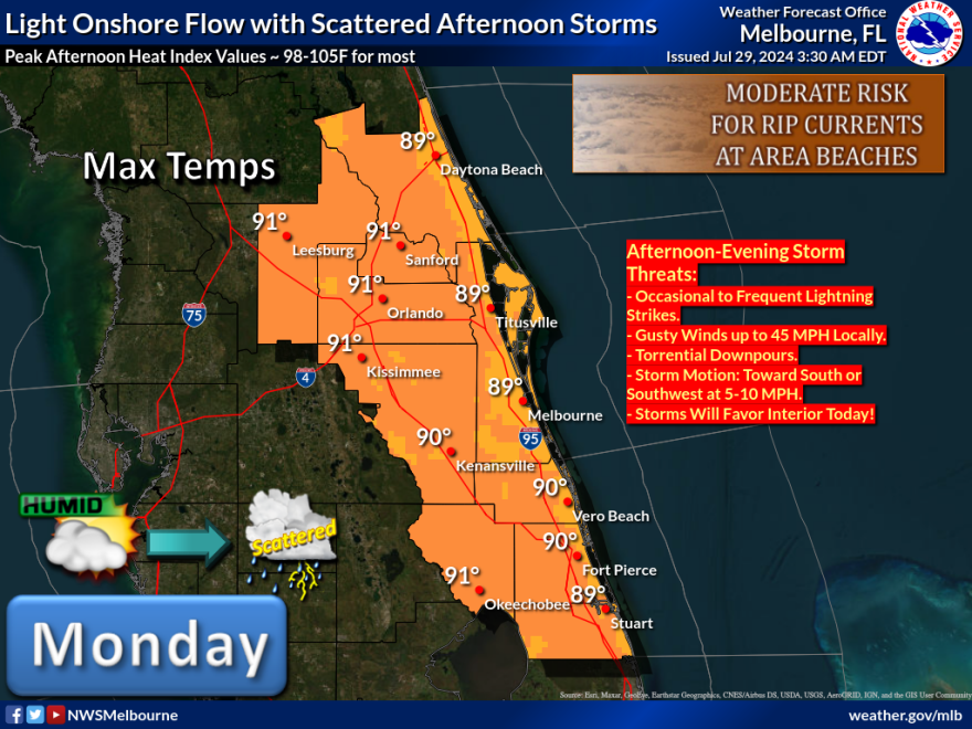
East-Central Florida - Monday July 29, 2024: Another hot and humid day Monday as the ongoing heat-wave continues to punish East-Central Florida with unusually high temperatures. The National Weather Service in Melbourne predicts highs in the upper 80s to low 90s, with peak heat indices, or feel like temperatures between 98 and 105 degrees for most.
An east coast sea breeze will move well inland today. That will spark scattered showers and lightning storms this afternoon. The most numerous and strongest storms will occur west of I-95.
A Moderate Risk for life-threatening rip currents continues at all central Florida Atlantic beaches.
EXCESSIVE HEAT IMPACT
Temperatures in the upper 80s to low 90s this afternoon, combined with high humidity, will produce peak heat index index values up to around 105, particularly across the interior west of I-95. If spending time outdoors, take breaks in an air conditioned building or shade and drink plenty of water to avoid heat stress. Increasing rain and cloud cover by mid to late afternoon may bring relief from the heat.
Feel like temperatures will rise even high by mid to late week due to a combination of high relative humidity and increasing temperatures. Peak afternoon heat indices are forecast reach up to 107 by mid week, and as high as 110 late in the week.
THUNDERSTORM IMPACT
Scattered lighting storms capable of gusty winds to 45 mph, frequent cloud to ground lightning, and torrential rainfall are forecast this afternoon and into the early evening. The highest chances will be across southwestern interior late this afternoon into the early evening near the sea breeze collision. Activity is forecast to generally clear up around 8 PM across east central Florida.
Daily afternoon isolated to scattered lightning storms are forecast to continue through the week and into the weekend. Stronger storms capable of gusty winds, frequent lighting, and torrential rainfall will be possible, especially Tuesday.
EXCESSIVE RAINFALL IMPACT
Storms and heavy showers will be capable of producing a quick 1 to 3 inches of rainfall in a short period of time. While most showers and storms are forecast to move slowly to the southwest, multiple boundary interactions could result in slow and erratic movement or training, resulting in locally high rainfall amounts of 4 inches or more.
High rainfall rates could result in ponding of water on roads or flooding of urban, low-lying, and poor drainage areas. Slow down if driving in torrential rain and avoid flooded roadways.
RIP CURRENT AND SURF IMPACT
A Moderate risk for dangerous rip currents continues at all central Florida Atlantic beaches. Always swim near a lifeguard, and never swim alone.
A Low to Moderate risk for dangerous rip currents is expected to continue through the week.


